
During this post-festive season, when evenings can seem especially long and monotonous, readers might like to consider occupying their time with the creation of a print room. This once-fashionable pursuit, which had its heyday in the second half of the 18th century, subsequently fell out of favour and only one intact example survives in Ireland: that at Castletown, County Kildare. The design and execution of print rooms was customarily left to women, although it evolved from the mostly-male habit of collecting valuable prints and storing these either in a cabinet or within albums. Later on prints might be hung in a chamber designated for the purpose, often kept shrouded in order the work avoided suffering light damage: while cheaper than paintings prints, especially those of larger dimensions could be expensive to produce. However, larger runs of prints in the 18th century, often reproductions of popular works of art, helped to bring down costs and make these pictures accessible to a broader market than had hitherto been the case. Cheaper prices led to greater disposability and the emergence of the print room, a phenomenon effectively unique to Britain and Ireland (although there were some instances of the vogue found in America).


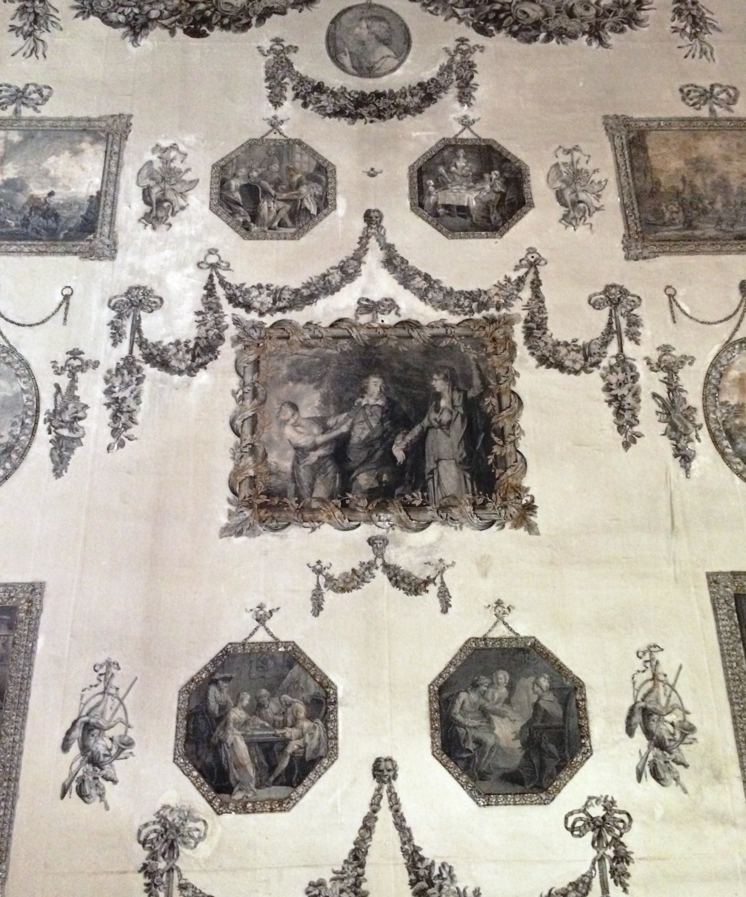
Located behind the house’s main staircase and part of an enfilade on the ground floor overlooking the garden, Castletown’s Print Room was created in 1768 by Lady Louisa Conolly. She had been collecting pictures for at least the previous six years, and in addition had gained experience through assisting in similar ventures with her sister Emily, Countess of Kildare at nearby Carton and with Lady Clanbrassil at Cypress Grove House, Templeogue, County Dublin. Both these rooms have since been lost. The project was a long time in gestation: in 1762 she wrote to her sister Lady Sarah Bunbury, ‘I always forget to thank you my Dear for the Prints you sent me, I hope you got them of Mrs Regnier, for I have a bill there, the two little ones that you admired so, are the very things I wanted, that of Helen is charming. I have not had time to do my Print room yet.’ It is likely the reason the Print Room took so many years coming into existence is both because the Conollys were preoccupied with other work at Castletown and because Lady Louisa did not want to rush preparing the layout of what is a larger space than that customarily used for such a purpose: the ceiling here, for example, is twenty-five feet high. As a result, an awful lot of prints were needed. As late as February 1768 she was still writing to her sister Lady Sarah, ‘…any time that you choose to go into a print Shop, I should be obliged to you, if you would buy me five or Six large Prints, there are some of Teniers engraved by LeBas, which I am told are larger than the common size, if you meet with any, pray send me a few.’ Working out the design for this room was a complex business, particularly since border frames for each of the frames also had to be prepared, as well as garlands, trophies and other elements of the overall decoration.


When Lady Louisa finally came to embark on the scheme, the prints were duly cut out and then glued onto lengths of warm off-white painted paper. These in turn were attached to the room’s walls on battens overlaid with cloth. As Ruth Johnstone has noted, in many cases Lady Louisa ‘made editorial decisions based on the outside shapes of images.’ Accordingly she altered the original rectangular format of forty-six images to either an octagonal, oval or circular shape, or to a rectangle with a convex top. Most likely because of the need to create a visual balance based on size and shape there is no overriding theme to the pictures but rather they reflect mid-18th century taste. A handful of images were included for a specific reason. In central position between the two windows, for example, is a print of Van Dyck’s portrait of the children of Charles I, a group including Lady Louisa’s great-grandfather Charles II. In the same position on the opposite wall is a print taken from Sir Joshua Reynolds’ portrait of Lady Louisa’s sister, the aforementioned Lady Sarah Bunbury (the original painting, incidentally, is now in the collection of Chicago’s Art Institute). Providing a centrepiece on the east and west walls are prints of the era’s most famous actor, David Garrick, and the room also includes a portrait of William Pitt, Earl of Chatham, rather surprising since he was a political opponent of Lady Louisa’s brother-in-law Henry Fox, first Baron Holland. Otherwise the sources were diverse, with a fondness for both pastoral and classical subjects taken from the works of diverse artists including Teniers, Greuze, Jan Steen and Claude Lorrain. Despite such dissimilitude, Castletown’s Print Room conveys an impression of homogeneity thanks to its designer’s careful preparation. Anyone intending to embark on a similar enterprise will find these long winter evenings perfect for similarly thorough planning.

Much more information on Castletown’s Print Room can be found in Ruth Johnstone’s essay on the subject including in the Office of Public Work’s 2011 publication Castletown: Decorative Arts.


